Imaging adds new dimension

Aerial oblique photography has become dramatically more popular in recent months for homeland security and emergency preparedness, and at the moment, it seems the sky is the limit for this specialized imaging technology that lets users see front and side views of buildings and other geographic features.
Aerial oblique photography has become dramatically more popular in recent months for homeland security and emergency preparedness, and at the moment, it seems the sky is the limit for this specialized imaging technology that lets users see front and side views of buildings and other geographic features.One company in particular, Pictometry International Corp. of Rochester, N.Y., has been flying high, recently signing contracts with public safety agencies in Massachusetts and Rhode Island as well as more than 140 counties. The Homeland Security Department is reimbursing some of its work.A privately held firm that in four years has grown to 90 employees, Pictometry also has an agreement to share its images with Microsoft Virtual Earth, an online mapping application. Following Hurricane Katrina, Pictometry and Microsoft offered free Internet access to Pictometry's before-and-after aerial oblique photos of New Orleans, Mississippi and other affected areas."It's an incredible tool for analyzing change," said Dante Pennacchia, Pictometry's chief marketing director. "Because of the oblique angle, you can see more of the changes."Unlike typical aerial photographs used for mapping -- overhead views looking down on rooftops -- aerial oblique photographs are taken at an angle to capture the fronts, sides and backs of buildings and other features.The company provided Gulf Coast images to the Homeland Security Department, Centers for Disease Control and Prevention and other federal agencies to assist in the hurricane recovery efforts, Pennacchia said.The aerial oblique images are used in combination with Global Positioning System devices to help 911 call centers locate cell phone callers. The detailed, full-color images also help fire, police and emergency management departments locate houses and plan for rescues and evacuations, Pennacchia said.Built into Pictometry's application is a measuring tool that lets a fire chief use one of its photos to estimate the height and elevation of a building and the width of its largest window to help plan a rescue.The aerial oblique photographs are more accurate in identifying and describing the location of a home than typical mapping software, which often estimates locations for specific addresses, Pennacchia said. For example, when a reporter searched for a home address with a popular Internet mapping tool recently, it positioned the home in the middle of a block, when the house actually is on a street corner."You don't want police to raid the wrong house. With public safety, you want to know the exact house," Pennacchia said.In Hilton Head, S.C., local officials are using Pictometry with fire and rescue dispatch systems, in addition to tax, development, environmental, planning and emergency management departments, among others."The Pictometry imagery and software have proved to be beneficial to almost all of our departments," Rich Hamilton, geographic IT administrator for Hilton Head, said in a press release. "The ease of use of the software has enabled it to become a valuable tool to a wide variety of our users, and new applications for it are continually being discovered."Pictometry uses automatic cameras mounted in Cessna 172 airplanes. The cameras snap aerial photographs from many angles while the plane flies over the same area several times. Images are taken from 5,000 feet and 2,500 feet.The company is working with systems integrators, including Northrop Grumman Corp. and Lockheed Martin Corp., to link its photographic tools to public safety dispatch systems, emergency management operations centers and command centers, Pennacchia said.In applying its skills to homeland security and public safety, Pictometry appears to be flying solo, although it has competitors in Israel and the United Kingdom. Pictometry recently signed an agreement with Norwegian mapping company Blom ASA to use Pictometry's technology in 13 countries in Europe.With Microsoft Virtual Earth, Pictometry plans to photograph selected major cities in the United States, but Microsoft Corp. spokeswoman Jamie Lee declined to name the cities."As far as I know, no one else is doing what Pictometry is doing," said Jay Grumme, president of Above All Photography Ltd. of Indianapolis, an aerial photography company with six employees. "I'd love to know what type of camera they are using. You need very high resolution."Grumme's company takes aerial oblique photographs primarily for real-estate developers, individuals and tax agencies, and primarily in the Midwest. His competition is mostly from solo freelance flyers, many of whom focus on shooting aerial photographs of celebrity homes and outdoor weddings.Grumme said the market for public safety aerial oblique photography might be limited once all the urban areas have been photographed. "I cannot see a market for oblique photographs of farmland," he said.But Pennacchia said aerial photography for emergency preparedness is experiencing rapid growth that he expects to continue, and Pictometry plans by the end of 2006 to double to 40 the number of planes it operates."We've grown from zero to having photographed 28 percent of the population centers," Pennacchia said.Staff Writer Alice Lipowicz can be reached at alipowicz@postnewsweektech.com.


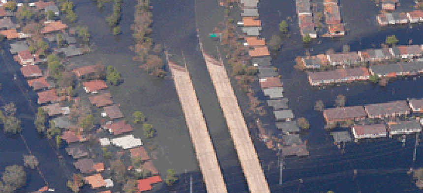
Shown is the the Morrison Road area off of Interstate 10 in New Orleans after Hurricand Katrina. Pictometry's measuring software, pre-storm images of the region and Change Analysis Software are helping agencies in the recovery effort and to plan for future emergencies.
Courtesy of Pictometry International
NEXT STORY: Homeland watch

