Location, location, location
Pitney Bowes sees geospatial software as key to fed sales.
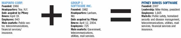
Pitney Bowes Inc. is merging its Group 1 Software Inc. and MapInfo Corp. business units into Pitney Bowes Software, a new unified entity that will make an aggressive effort to become a major government provider of geospatial software.
Pitney Bowes developed the business strategy in 2002, as part of an effort to shed its reputation as a business mailing com-pany and become a software provider. Its first major acquisition was the Lanham, Md.-based Group 1 in 2004, which developed enterprise data quality and integration software for local, state and federal agencies.
The acquisition of MapInfo, based in Troy, N.Y., was completed in April, said Bernard Gracy, vice president of strategy and business development at Pitney Bowes. The two units will merge their operations in the next several months.
"There is a very carefully planned transition period," Gracy said. MapInfo and Group 1 have well-known brand equity "and we want to make sure that that brand equity gets carefully transitioned to this new unit. That's really the most important part of this integration."
It's also important for the federal sector and the major government integrators to know what Pitney Bowes Software now delivers, he added. "In the government space, the systems integrators are key to our mutual success."
The merger was not designed to save money or reduce overhead, Gracy said. The two wholly owned subsidiaries have a total of 1,665 employees. "The driver here was all the complementary assets that both parties have," he said. "It's really more focused on delivering more value to customers or more value to the partners."
Nevertheless, "there'll be a good synergy there in terms of cost reduction," said David Sonnen, senior consultant for spatial information management at technology research company IDC Corp. "One of the brilliant parts of the MapInfo acquisition was [that] they took MapInfo out of the public com-pany arena, and that dropped about $15 million a year directly to the profit side." There will be some additional efficiencies and cost reductions, he added.
MapInfo specializes in location intelligence software and has extensive predictive analytic capabilities and data modeling. "The key value is the ability to conflate multiple geospatial datasets so that government agencies can create valuable information," Gracy said.
Group 1 had a small but rapidly growing division in Boulder, Colo., that sold Pitney Bowes' business geographics product line. Pitney Bowes officials said they believed the growth potential to be almost unlimited, Gracy said.
He declined to say which federal agencies the newly integrated company will target but said geospatial software is increasingly used in public safety, homeland security and disease management applications.
A recent IDC study found that 40 percent of federal agencies are using geospatial technology in some form. "That's pretty significant," Sonnen said.
The merger positions Pitney Bowes Software to develop business with the Homeland Security Department, National Geospatial-Intelligence Agency, Census Bureau, U.S. Geological Survey and Federal Emergency Management Agency, he said.
"They are looking for geospatial solutions to large processes, whether it's risk mitigation, emergency response, regional distribution of tax income or environmental impact," he said. "Those are pretty significant areas of concern for federal agencies and, of course, for state and local as well."
Sonnen said he believes Pitney Bowes has put together a strong offering for government organizations that want geospatial technologies for large systems, such as DHS, which is a major user of location-specific technology. But the company faces stiff competition for government sales from Oracle Corp., ESRI Inc. and others, he said.
Oracle is the firmly established leader in data management services in the government and commercial space with an estimated combined market share of 80 percent to 90 percent, according to IDC.
Sonnen said it's probably too late for Pitney Bowes Software to try to win contracts for the 2010 census because the Census Bureau has already made its technology decisions. "The underlying data management technology is Oracle's ? that's a done deal," he said.
Pitney Bowes' primary competitor, however, is ESRI, which is already well-established in the government market, Sonnen said. Adding to the Redlands, Calif., company's market share is its recognition of the government's need for more broadly distributed location intelligence systems. "That's where the competition will occur ? to see who can adapt to the more broadly distributed systems the fastest," Sonnen said.
ESRI's strength is as a stand-alone, vertically integrated technology, whereas MapInfo positions itself as a technology that can operate more easily in distributed environments, Sonnen said. "ESRI has tried to reorient its software and business model to this more distributed enterprise approach," he said. "It'll be a really interesting fight."
But Gracy said he believes MapInfo is in a niche by itself. "People say, 'Well, they have visualization [capabilities], so are they competing against Microsoft and Google?' In many ways, they're partners."
MapInfo's visualization power is more of a business information tool than a navigational aid, he said. It enables users to get location information as part of the data needed to make good business decisions.
Sonnen said he is not surprised that the company plans to take several months to completely integrate the new entity because Pitney Bowes is conservative, deliberative and highly respectful of the channels and its customers.
But if MapInfo and Group 1 can pull off their merger, he added, they will have "positioned themselves brilliantly for this emerging enterprise market for geospatial technology. If they can't pull it off, then ESRI, Oracle, and the other players out there will eat their lunch."
At a Glance | Pitney Bowes merges units
Associate Editor David Hubler can be reached at dhubler@1105govinfo.com.
NEXT STORY: Comtech gets Army satellite services order