Fine tuning needed
Complexity, lack of standards stymie common operating picture efforts.
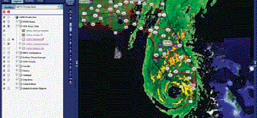
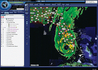
Development of common operating pictures for homeland security continues to be hampered by complexity, ambiguous goals and a lack of global standards for data exchange.And those difficulties are likely to apply to the Homeland Security Department's little-publicized national common operating picture, launched in May, IT experts said.All common operating pictures face similar challenges. It is relatively easy to develop a simple, map-based common view. However, combining one with other visual information, deciding which data to bring in and integrating it in real time is not so simple.Common operating pictures, also known as common operational pictures, are computer displays created to provide multiple users with a real-time view, also called situational awareness, of a series of events, such as rescue activities following an attack or natural disaster.DHS' national common operating picture uses National Geospatial-Intelligence Agency mapping capabilities and is incorporating dynamic, real-time data, said Steven Alness, a member of the geospatial agency's support team to DHS. "It is a work in progress," he said."Getting a map is not difficult," said John Halsema, director of technology for advanced security solutions at geographic software developer Intergraph Corp., Huntsville, Ala. "Getting a map and fusing data in real time is much more challenging, and we're not there yet. We haven't gotten to the point of being able to track assets, such as vehicles and helicopters, in real time."Halsema declined to comment directly about the DHS national common operating picture, referring calls to the agency. Departmental officials did not respond to requests for comment.A basic common operating picture example would be a satellite map of an incident, overlaid with data about the locations of buildings, streets, first responders on the scene, vehicles, power lines and other information. Ideally, the maps are combined with incoming information in real time to create a visual representation of post-disaster response that those viewing the aggregated data can use to make their response more effective.Because each disaster is different, the operating pictures are different and may evolve into different formats as an incident unfolds.The Homeland Security Department earlier this year activated its Common Operating Picture for the National Operations Center. The agency rushed creation of it immediately after Hurricane Katrina to create situational awareness. Over the following months, those efforts became the national system."As part of an incrementally phased development effort, the DHS Common Operating Picture/Common Operating Database system has focused on the 2006 hurricane season and has been implemented in selected offices, components and interagency operation centers," states a recent DHS fact sheet. "Subsequently, the COP/COD system will be implemented nationwide for all homeland security partners, for all hazards and for all threats."Parallel efforts on other common operating pictures ? to map airports and other critical infrastructure, offer maritime situational awareness and do border surveillance in the Secure Border Initiative Network ? are also continuing at DHS, according to several geospatial experts involved in those efforts.A source of data for the DHS national common operating picture is the National Geospatial-Intelligence Agency and its Palanterra application, a map-based common operating picture. It includes overlays for critical infrastructure, including transportation, medical centers, water plants, power facilities and some financial and IT infrastructure, said Mark Riccio, senior adviser for geospatial analysis to the agency."Palanterra was an outgrowth of 9/11 to provide a mission-defined operational picture," Riccio said. "The primary consumers are the federal community."Agencies used Palanterra during President Reagan's funeral in Washington and at Super Bowl games for situational awareness and to coordinate federal activities during those events, he said.To become more robust with real-time data, common operating pictures must overcome technical and organizational concerns, Halsema and others said. Although many first-response agencies have their own map-based operating pictures or something approximating them, it's problematic to integrate such pictures from several agencies into a single view with a clearly defined mission."You want to have a common operating picture that is meaningful, but there are always ambiguities that need to be resolved," Halsema said.For example, tracking a person through buildings, streets and security zones, while easy in theory, is difficult in practice, because it requires seamless, real-time integration of numerous programs. If the person disappears into a gap between coverage of video cameras, a separate check by human eyes may be needed to ensure that it is the same person who reappears on the second camera.One obstacle to quick integration of data is the dearth of global standards for sharing data. Without such standards, IT programmers must write instructions each time they import new data sets into a common operating picture.One group working on data-exchange standards is the Network Centric Operations Industry Consortium, formed in 2004 to foster information interoperability."Standards need to be developed for common operating pictures so you can communicate effectively in real time," said Nelson Santini, spokesman for the industry consortium and marketing manager for DataPath Inc., a maker of satellite networks in Duluth, Ga. Post-disaster common operating pictures are put together differently each time, depending on which agencies are involved, their missions and the type of disaster, he said.Ideally, systems and standards would be in place so that such operating pictures could be created more rapidly and effectively, Santini said. The solutions will involve not only technology and standards, but also organizational advances, he said."The questions are who has control of the common operating picture and who's in charge of it," Santini said. "If you don't define it ahead of time, you'll have the same problems we experienced after Katrina."Decisions about sharing data among federal, state and local agencies also are affecting development of common operating pictures for airports, said Michael Borcherding, president of Herndon, Va., systems integrator Abeo Corp. and director of the Strategic Infrastructure Protection Consortium, an industry group pursuing integrated security contracts. The group has installed its solution, funded by the Transportation Security Administration, at regional airports in Tallahassee, Fla., and Helena, Mont."The problem is that there are many users and many jurisdictions looking at the common operating picture," Borcherding said in an interview. "The technology to set it up is available, but how the information flows up and down has not been worked out yet."
A simple plan
Hills to climb
Staff Writer Alice Lipowicz can be reached at alipowicz@postnewsweektech.com.
Palanterra, a map-based common operating picture of the National Geospatial-Intelligence Agency, shows Hurricane Wilma over Florida last year.
National Geospatial-Intelligence Agency
A simple plan
Hills to climb
Staff Writer Alice Lipowicz can be reached at alipowicz@postnewsweektech.com.
NEXT STORY: Revamped Business.gov to cater to small biz